Butterfly Lake
Thursday, July 13, 2006
 Butterfly Lake is nestled in the mountains separating the Cheakamus and Squamish Rivers. We planned to visit it using a crossover, starting in the Cheakamus Valley and ending in the Squamish Valley. We met at St. David’s Church at 8:00 a.m. and headed to Squamish in two cars, making a first stop at Brackendale Café. After coffee, muffins, hash browns etc., we continued in convoy, crossing Cheekye Bridge over the Cheakamus River, where Squamish Valley Road veers left and Paradise Valley Road right. We took the Squamish Valley Road for about twelve kilometres to the single-lane Pilchuck Creek Bridge and, about a kilometre further on, took the road on the right, parking one of our vehicles by the closed gate. All of us climbed into the other vehicle, drove back to Cheekye and turned left onto Paradise Valley Road. We passed Tenderfoot Hatchery where pavement ends, continued to the single-lane Jack Webster Bridge over Culliton Creek and stopped at Misty’s Lane, the next road on the left.
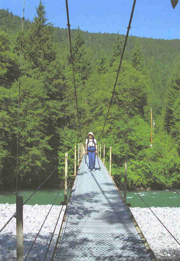
It is best to park by the main road and walk into Misty’s Lane for reasons which will become apparent. In the 1960’s, a major flood in the Upper Cheakamus Valley destroyed both Culliton Creek Bridge and Misty’s Lane’s Cheakamus Bridge. This left residents isolated, with their vehicles stranded on one side or the other of the disruption. This situation continued for some time until Jack Webster publicized the issue on his radio program and the authorities built a new Culliton Creek Bridge, locally nicknamed Jack Webster Bridge. In addition, they provided a pedestrian suspension bridge over the Cheakamus River linking Misty’s Lane with the seven houses on the river’s west bank. Parking spaces for use by west bank residents line Misty’s Lane itself. When we first used to cross the bridge, there was an old car with a key in the ignition so that west side residents could carry goods to their houses. Just lately the vehicle has been replaced by a wheelbarrow.
 We crossed the suspension bridge (elevation 100m) at about half past ten and followed the old road as it turned parallel with the river behind the river-fronting lots. Notices advised us not to trespass, to beware of dogs and to take note that the property was not for sale. After the last house was passed, the road became more of a trail and soon we took a sharp switchback left and climbed a rocky slope to reach an old logging road at a higher level. A wide pleasant green mossy route continued with dustings of cotton from the poplar trees. When the trail started to rise, sunlight indicated that we were coming out to an open area with views (elevation 220m). We took a refreshment break and enjoyed the southerly views over the Cheakamus Valley. The trail became steeper and rockier, passing through trees, with a high mountain slope on the left side. This continued for some time to another more open level area with views (elevation 400m). We could see the railway line on the other side of the Cheakamus River as well as sections of the Cheakamus Canyon Trail itself. In the north, the wide scar of the Sea-to-Sky Highway was apparent as it descended to Chance Creek and the Rubble Creek turnoff to Garibaldi. The grade became more gentle up to a ridge (420m) where we descended on a rocky path to reach Butterfly Lake Road at the bottom. A one-minute jog to the left brought us to Pilchuck Lake (350m) where there was a diving board and the Tantalus mountains provided a great backdrop for us to enjoy a well-earned lunch (12:30 p.m.) One of our group took a swim to cool off after the hike up in a 30 degree temperature.
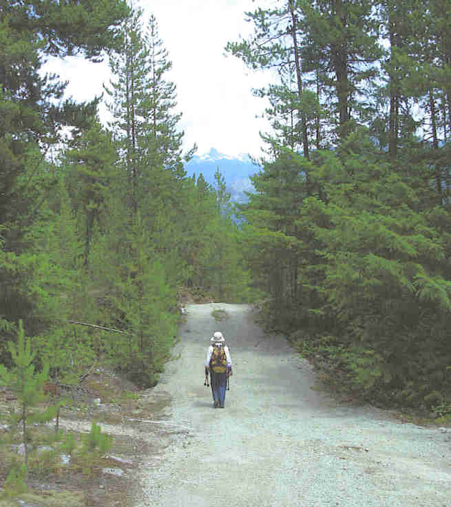 After a lunch stop of about an hour, we started the trip to Butterfly Lake. We had been told that there would be a climb up and down to reach the lake but we were still not prepared for the amount of work involved. We climbed gradually to a locked gate after which there were notices declaring the obvious, e.g. Use 4-wheel Drive or Loose Gravel. The road became steeper and there were ups and downs before we came to the highest point (460m). Here a motley collection of signs on the trees greeted us - Highway 99, Granville Street, Railroad Crossing, Bus Stop, Kiss-and-Ride, Airport, Reduce Speed. After a descent with views ahead to Black Tusk and steep sections where you walked as if on ball bearings, we reached Butterfly Lake (390m). The two kilometres from Pilchuck Lake had taken an hour.
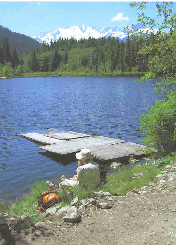
 The lake is butterfly-shaped and we were sitting on a dock at the edge of one wing. Houses dotted the far shoreline. The lake is used by residents who like to fish or swim. After a long refreshment stop to enjoy the lake, we set off back. The driver of a car arriving as we were leaving checked that we were fine and did not need help; we probably looked as if we could use some.
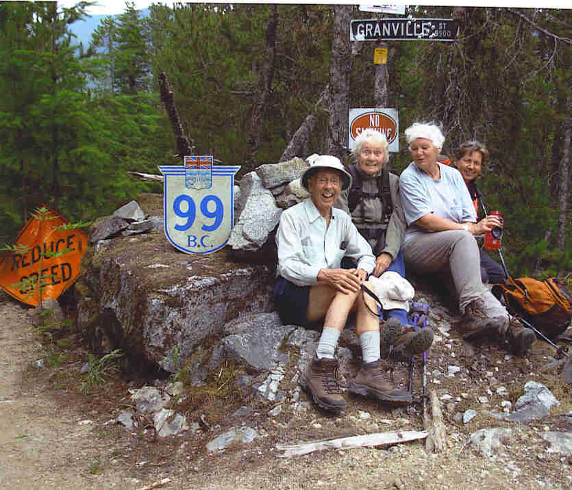
The high point of the road offered a photo op. before we carried on down to reach Pilchuck Lake. Just over an hour of road walking got us to our Squamish Valley vehicle. We piled in, picked up the other vehicle at Misty’s Lane and headed for the White Spot in Squamish. We all enjoyed the adventure but another time I’ll just park at Misty’s Lane, go up to Pilchuck Lane for lunch, on to Butterfly Lake for tea and back to the car at day’s end.
Return to Further Walks
Archives
![]()